G1: Oral Presentation C Thursday, 1:30 – 2:00
pm C French River Room
Enterprise
GIS Deployment: The Minneapolis Model
Gary Criter
City of Minneapolis
331
2nd Avenue Suite 220
Minneapolis, MN
55401
gary.criter@ci.minneapolis.mn.us
Like many large cities, Minneapolis, Minnesota,
USA, has begun deployment of their next generation Geographic Information System
(GIS). The GIS 2000 program is a departure from the traditional
department-by-department application development strategy indicative of the
1980s and 90s. City leadership mandated the use of a business process driven
approach for the citywide initiative. This approach was based on an enterprise
vision of providing City staff with a supportive technical, information and
organizational environment for improving the level of services to the citizens
of Minneapolis. The software selected for the program includes ESRI’s ArcIMS
and ArcGIS software and Oracle’s Spatial 8i database management system.
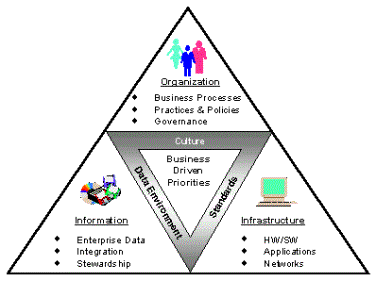
As identified in Figure 1, the City’s vision is articulated through their
priorities that define the culture of the organization, the standards that drive
enterprise technology acquisition, and the data environment that enables access
to the organization’s enterprise information.
Figure
1: The Minneapolis Model
The intricacies of the GIS program required the
assembly and governance of a diverse group of both internal and external
specialists. Their objective: to build an organizational, information and
technical framework necessary to support user needs across the City. By
emphasizing business process as well as organizational change, establishing new
ways of thinking and approaching problems, connecting people and groups, giving
them information and motivating them, this partnership has helped transform the
organization of which it is a part. Key partners include: all City departments
and affiliated agencies; Hennepin County, Minnesota; Oracle Corporation;
Environment Systems Research Institute; and EMA, Inc. The collaborative
partnership approach serves as a mechanism for building relationships among all
stakeholders, helping them to expand their effectiveness and reach of the GIS
program.
This presentation will detail the results of this
collaborative partnership, which has allowed for unprecedented influence and
participation on the part of the departments and agencies involved, enabling
them to transform the very nature of their organization and inter-relationships.